


Analysis
A depth without its measurement path, reference and unit is an incomplete engineering statement. Three numbers can describe the same bottomhole position while answering different questions: how far the borehole travels, how far down it goes, and where it sits relative to sea level. Confusing those questions can distort a geological correlation, a pressure calculation or a drilling comparison even when every copied number is accurate.
This guide separates published observations from calculations and fictional teaching cases. The real example is Norwegian Offshore Directorate wellbore 16/11-1 S, source identifier 112, checked on 8 November 2026. The geometry and drilling-fluid cases are independent mathematical examples. They do not reconstruct that borehole, estimate its present pressure or prescribe an operating programme.
1. Start with the coordinate, not the largest number
Measured depth, MD, describes distance along a borehole. True vertical depth, TVD, describes the vertical separation from a stated reference. With the same starting point, a straight vertical hole has equal MD and TVD; a deviated path generally has a longer MD. A published total depth should therefore retain its depth type instead of being reduced to a generic depth field.
SLB’s terminology distinguishes these uses, while BOEM’s borehole field definitions explicitly reference total MD and TVD to the rig kelly bushing. That is evidence about those fields, not permission to assign the same reference to every other dataset. A comparable record needs the quantity, unit, zero point, sign convention and source identity together.
2. A datum shift is a vertical calculation
Define elevation as positive upward from mean sea level, MSL, and depth below MSL as positive downward. If the rotary kelly bushing, RKB, has elevation z_RKB, then depth_MSL = TVD_RKB − z_RKB. The subtraction changes the vertical reference; it does not convert MD into TVD. A different zero point or sign convention requires a separately stated transformation.
The historical UKOOA P7/2000 Revision 5 format distinguishes zero measured depth, zero true vertical depth and the permanent vertical datum. Its October 2002 terminology is a useful explanation of why a rig change or sidetrack can change the reference. It is not presented here as a new or mandatory reporting standard. Energistics’ WITSML 2.0 coordinate definition likewise carries datum and unit explicitly.
3. Read one documented borehole carefully
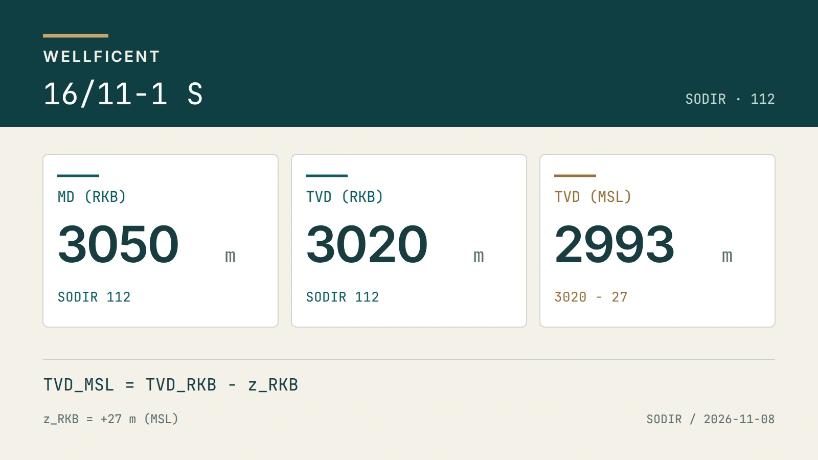
SODIR reports 16/11-1 S with total MD 3,050 m RKB, final TVD 3,020 m RKB, RKB elevation 27 m above MSL and water depth 67 m. These are source-reported values, not four measurements newly taken by Wellficent. The matching Well Atlas record is no-sodir-112: its sourceRecordId is 112 and its MD/TVD fields preserve the RKB reference. A text search also returns 7216/11-1 S, so a similar name alone is insufficient identification.
Under the sign convention above, the reported TVD gives 3,020 − 27 = 2,993 m below MSL. Subtracting the 67 m water depth gives a calculated 2,926 m vertical separation below the sea floor. Neither derived value replaces the source fields or constitutes an independent survey. In particular, subtracting 27 from the 3,050 m MD would not produce a valid subsea TVD.
4. A final inclination cannot replace a deviation survey
For an ideal straight segment of length L inclined by angle i from vertical, the vertical increment is L × cos(i). At L = 3,000 m, inclinations of 0°, 30° and 60° give vertical increments of 3,000 m, approximately 2,598.1 m and 1,500 m. The chart reproduces these fictional straight-segment calculations, rounded to 0.1 m. They are geometry checks, not drilled trajectories.
A real borehole changes inclination and azimuth along its path. Reconstructing TVD requires the appropriate survey stations, references and calculation method, with uncertainty and quality checks. Applying the maximum or final inclination to the entire MD invents a trajectory. The reported 3,050 and 3,020 m totals do not reveal all intermediate depths, lateral displacement, formation dip or true reservoir thickness.
5. Hydrostatic pressure uses vertical fluid height
For a static, continuous fluid column of uniform density, the pressure increment is density × gravitational acceleration × vertical height. In conventional oilfield units the rounded relation is pressure in psi = 0.052 × mud weight in pounds per US gallon × TVD in feet. This is an increment from the column’s reference pressure, not automatically an absolute reservoir pressure.
A fictional 12 ppg column spanning 10,000 ft vertically gives 6,240 psi using that coefficient. Substituting an unrelated 15,000 ft MD gives 9,360 psi, an overstatement of 3,120 psi or 50%. The erroneous result illustrates the reference mistake; it is not a second observation. Circulating friction, surface pressure, compressibility, temperature, gas and changing density require additional treatment. No mud-weight or well-control instruction is inferred from this classroom case.
6. A LAS file is a data contract
The USGS explanation of LAS identifies separate version, well, curve and ASCII-data sections. Read the file’s actual version and wrapping declaration, start/stop depths, step, curve order, mnemonics, units and null definition before interpreting the samples. A file extension or familiar curve name does not establish a complete depth reference, calibration history or permission to reuse the material.
If a teaching file declares NULL = −999.25, that value means missing in that file; it is not a physical log response or a universal sentinel to impose on all other files. Preserve genuine zero responses separately. A negative step can describe a decreasing-depth sequence, so reordering samples without preserving the source relationship is also a transformation that needs documenting. Unknown units remain unknown.
7. Depth matching and thickness require more evidence
Formation tops, cuttings, core intervals, wireline logs and drilling measurements need not share the same depth acquisition or correction history. Before overlaying them, establish the wellbore branch, run, reference and any documented depth shift. Keep the original values and the transformation separately. A visually attractive overlay does not validate a correlation.
An interval measured along hole is not automatically its true vertical thickness, and a vertical thickness is not necessarily true stratigraphic thickness in dipping beds. The well path and structural geometry matter. A gap between two reported formation tops can be a derived interval within a compatible reference; it is not proof that a contact was directly measured at every intermediate depth.
8. Keep the atlas snapshot separate from today’s source page
The Well Atlas record used here retains its existing source-check date of 2 October 2026. This article’s source reading on 8 November does not refresh the whole registry, certify the well’s present operational state or change the historical availability of its measurements. The current primary page and the retained reviewed edition are separate evidence objects, even when their displayed depth values agree.
Use the source-scoped record identifier to retrieve the documented borehole, preserve its attribution and terms, and follow its source record URL. The Norwegian Offshore Directorate attribution and NLOD 2.0 terms travel with the registry response. Public access does not settle every downstream reuse question. An absent temperature, depth datum or original available-at timestamp must not be filled by assuming today’s download was historically known.
9. Build an auditable engineering decision
A useful review package records the original document and revision, source access time, exact field or curve, unit and reference, branch identity, calculation inputs, sign convention, rounding and unresolved limitations. Store derived depths alongside their formula rather than silently overwriting the source total. A second calculation should reproduce the result from those inputs without needing an undocumented plotting adjustment.
These distinctions have economic value because interval placement, completion design and comparison of drilling progress depend on consistent coordinates. This guide assigns no invented dollar benefit to correcting a datum. A financial assessment would also need the actual programme, costs, uncertainty and consequences. The supported conclusion is narrower and useful: establish the coordinate contract before converting a depth into an engineering claim.